XAPO Configuration for Accela GIS
Civic Platform can integrate with an external address, parcel, and owner (XAPO) data source. Accela GIS supports the mapping of reference object and custom fields between Civic Platform and an XAPO data source via the agency's map service. Accela GIS supports XAPO integration with map services provided by ArcGIS Server and ArcGIS Online.
-
Set the Feature Count Limit to control the maximum number of GIS records returned by an XAPO query. The default Feature Count Limit is 200.Note: Setting the Feature Count Limit helps prevent users from submitting long-running query transactions. For example, if a user submits an address query on the XAPO data source which returns a large amount of data, the user is prompted to narrow the search criteria if the search results exceed the configured Feature Count Limit. When using a GIS REST API to query XAPO data, the API caller should submit the query with a narrower search criteria or set the maxRows page setting to a number less than the Feature Count Limit.
-
Define the XAPO Configuration mapping of address, parcel, and owner data between Civic Platform and an XAPO data source.
Civic Platform standard choices also need to be configured to point the Civic Platform environment to the GIS (JavaScript version) data mappings. For details, see Configuring XAPO in Civic Platform.
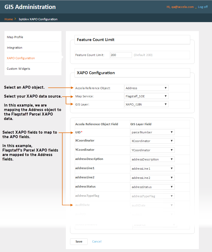
Mapping XAPO fields to APO fields
- Log into the GIS Administration site.
- From the agency's home page, click XAPO Configuration on the left navigation pane.
- On the XAPO Configuration pane, select the Accela Reference Object, either address, parcel, or owner.
- Select the Map Service and GIS Layer. Your selected map
service provides the XAPO data to be mapped to the Civic Platform APO
object. After you select a Map Service, the GIS Layer
drop-down list populates with all the related map layers.Note: Select the same Map Service across all Address, Parcel, and Owner objects.
- For each of the object fields used in your agency's Civic Platform integration
environment, select its corresponding GIS Layer field from your XAPO data
source. Note: The UID field which is used as the object identifier must be mapped to the GIS layer's identifier field. The other Civic Platform fields can be mapped according to your agency's data requirements.
The following diagram shows a sample mapping of the Address fields (fields that are not mapped are not shown in the sample diagram for simplicity):
-
After you are done with the Address object field mappings, click Save.
- Repeat the above procedure for Address, Parcel, and Owner objects.
Reference APO Object Fields
The following table lists the Civic Platform fields for each of the Accela reference objects (Address, Parcel, and Owner):
| Reference Object | Reference Object Fields |
|---|---|
| Address | xCoordinator, yCoordinator, addressDescription, addressLine1, addressLine2, addressStatus, addressTypeFlag, auditDate, auditID, auditStatus, city, country, countryCode, county, distance, eventID, fullAddress, houseFractionEnd, houseFractionStart, houseNumberAlphaEnd, houseNumberAlphaStart, houseNumberEnd, houseNumberStart, inspectionDistrict, inspectionDistrictPrefix, levelPrefix, levelNumberStart, levelNumberEnd, lot, neighborhood, neighborhoodPrefix, primaryFlag, secondaryRoad, secondaryRoadNumber, sourceFlag, state, streetDirection, streetName, streetPrefix, streetSuffix, streetSuffixdirection, subdivision, unitEnd, unitStart, unitType, zip |
| Owner | UID, address, address1, address2, address3, auditDate, auditID, auditStatus, city, country, email, eventID, fax, faxCountryCode, isPrimary, ivrPinNumber, ivrUserNumber, mailAddress, mailAddress1, mailAddress2, mailAddress3, mailCity, mailCountry, mailState, mailZip, ownerFirstName, ownerFullName, ownerLastName, ownerMiddleName, ownerStatus, ownerTitle, phone, phoneCountryCode, sourceSeqNumber, state, taxID, zip |
| Parcel | UID, auditDate, auditID, auditStatus, block, book, censusTract, councilDistrict, eventID, exemptValue, improvedValue, inspectionDistrict, landValue, legalDesc, lot, mapNo, mapRef, page, parcel, parcelArea, parcelNumber, parcelStatus, primaryParcelFlag, planArea, range, section, sourceSeqNumber, subDivision, supervisorDistrict, township, tract |
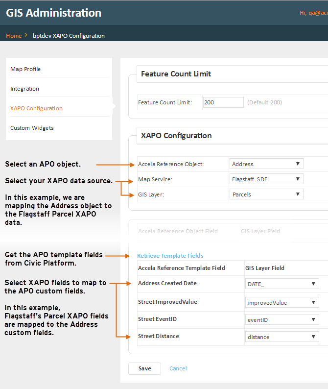
Mapping XAPO fields to APO template fields
An address, parcel, or owner (APO) template is a collection of custom fields that can be added to APO reference data. For example, in addition to the standard Civic Platform reference address fields, your agency can collect additional agency-specific information that is associated with each reference address. As a GIS administrator, you can map the reference template fields to your agency's GIS map service fields to enable automatic retrieval of your agency's data into the custom fields.
To map your agency's GIS layer fields to the APO template fields:
- Log into the GIS Administration site.
- From the agency's home page, click XAPO Configuration on the left navigation pane.
- On the XAPO Configuration pane, select the Accela Reference Object: either address, parcel, or owner.
- Select the Map Service and GIS Layer. Your selected map
service provides the XAPO data to be mapped to the Civic Platform APO
object. When you select a Map Service, the GIS Layer drop-down
list populates with the map layers from your selected map
service.Note: Select the same Map Service across all Address, Parcel, and Owner objects.
- Click Retrieve Template Fields. When you click Retrieve Template Fields, Accela GIS fetches all enabled reference templates from Civic Platform for the selected object type, and lists each template's enabled custom fields.
- For each of the custom fields used in your agency's Civic Platform
integration environment, select its corresponding GIS Layer field from your
XAPO data source.
The following diagram shows a sample mapping of the
Address template custom fields:
-
After you are done with the template custom field mappings, click Save.
- Repeat the above procedure for Address, Parcel, and Owner objects.