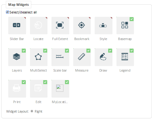
Map Widgets
A map widget is a tool that facilitates a specific function or task on a map. The Map Widgets section allows the administrator to enable or disable map widgets for the user group. The available map widgets include out-of-the-box Accela GIS widgets and custom widgets.
To enable or disable a map widget for a user group, check or uncheck its corresponding checkbox. Map widgets without a checkbox are always available to users and are non-configurable.
The following diagram shows the Map Widgets section. In this example, MyLocation is a custom widget:
The following table describes the out-of-the-box widgets. These widgets are always available and visible to users.
| Slider Bar | Zooms in and out. |
| Full Extent | Resets the map display to the agency’s default location. |
| Bookmark | Used for bookmarking locations and using the browser current location. |
| Style | Displays cluster markers, heat map, or pin map. |
The following table describes the configurable widgets which can be enabled or disabled for users.
| Basemap | Shows a basemap gallery which allows users to choose a geographical background. |
| Layers | Shows the available and visible map layers provided by the map service. The Layers panel allows users to manipulate the display of the map layers. Similar to the Map Widget settings, the Map Layer Settings are configured on the User Group page. |
| MultiSelect | Selects multiple points on the map to allow users to select multiple GIS objects for data viewing and analysis. |
| Scale bar | Shows the map scale, as provided by the map service. |
| Measure | Used for bookmarking locations and using the browser current location. |
| Draw | Used for map redlining and annotations. |
| Legend | Describes the symbols used on the map. |
| Exports the current map to a selected format. | |
| Edit | Used for editing and creating GIS objects on map layers. |