Map Service Provider Settings
This topic describes the map service settings for each supported map service provider type:
After configuring the map provider connection parameters, you can click the Retrieve Service link to retrieve the available Map service layers and configure each layer's ID field.
Map Service Settings Fields for ESRI ArcGIS Server
| Map Service Provider | Choose ESRI ArcGIS Server. |
| Map Server | The ArcGIS Server name or IP address |
| Port | The port number that corresponds to the map server’s IP address. The default port number for the HTTP server is 80 while the default port number for the HTTPS server is 443. |
| Use HTTPS Scheme | Indicates whether or not to support HTTPS to communicate between Accela GIS Server and ArcGIS Image Server. |
| Instance | The server instance. The default value that populates this field is arcgis. |
| User Name |
The ArcGIS Image Server user name. For more information about how to configure ArcGIS server security, see "Configuring ArcGIS Server security" on the ArcGIS Resources web site. |
| Password |
The ArcGIS Image Server password. For more information about how to configure ArcGIS server security, see "Configuring ArcGIS Server security" on the ArcGIS Resources web site. |
| Retrieve Service | Click this link to see a list of map services on the Map Service drop-down list and to retrieve map service information from your map provider. |
| Map Service |
If you retrieve a map service from ArcGIS Image Server, this drop-down list populates with map services that you have published to the root folder or its subfolders in ArcGIS Server. Select a map service from the drop-down list. For more information about how to publish map services in ArcGIS Server, see “Setting up Map Functionality” in the Accela GIS for ArcGIS Server Configuration Guide. |
| Default |
This check box applies to agencies that use multiple map services to create map mashups in one integration environment. Mark this check box to set a map service as the default. When you mark this check box, common settings, such as the initial extent of the selected map service, display in the map viewer. If your agency uses map services from ArcGIS Server and Bing Maps or from ArcGIS Server and ArcGIS Online Base Map, set an ArcGIS Server map service as the default map service. You cannot set a map service from Bing Maps or ArcGIS Online Base Map as the default map service in an integration environment with the map mashups. Only one map service can be the default. |
Map Service Settings Fields for OGC Map Service
| Map Service Provider | Choose OGC Map Service. |
| OGC WMS Service | The web mapping service URL for an Open Geospatial Consortium map provider. The web mapping service URL must come from the same data source as the web feature service URL. |
| OGC WFS Service | The web feature service URL for an Open Geospatial Consortium map provider. The web feature service URL must come from the same data source as the web mapping service URL. |
| Retrieve Service | Click this link to see a list of map services on the Map Service drop-down list and to retrieve map service information from your map provider. |
| Default |
This check box applies to agencies that use multiple map services to create map mashups in one integration environment. Mark this check box to set a map service as the default. When you mark this check box, common settings, such as the initial extent of the selected map service, display in the map viewer.Only one map service can be the default. |
Map Service Settings Fields for ArcGIS Online Web Map
| Map Service Provider | Choose ESRI ArcGIS Online. |
| User Name | If you are using ESRI ArcGIS Online Web Map as the map provider, enter the agency's subscription user account for ArcGIS Online. |
| Password | The agency's subscription account password for ArcGIS Online Web Map. |
| Retrieve Service | Retrieves the list of your published web maps from ArcGIS Online and populates the Map Service drop-down list. See Map service layers. |
| Map Service | A dropdown list that displays the web maps that you have published to ArcGIS Online. Select a web map as the map service. |
Map Service Settings Fields for ESRI Image Server
| Map Service Provider | Choose ESRI Image Server. |
| Map Server | The ArcGIS Image Server name or IP address |
| Port | The port number that corresponds to the map server’s IP address. The default port number for the HTTP server is 80 while the default port number for the HTTPS server is 443. |
| Use HTTPS Scheme | Indicates whether or not to support HTTPS to communicate between Accela GIS Server and ArcGIS Image Server. |
| Instance | The server instance. The default value that populates this field is arcgis. |
| User Name |
The ArcGIS Image Server user name. For more information about how to configure ArcGIS server security, see "Configuring ArcGIS Server security" on the ArcGIS Resources web site. |
| Password |
The ArcGIS Image Server password. For more information about how to configure ArcGIS server security, see "Configuring ArcGIS Server security" on the ArcGIS Resources web site. |
| Retrieve Service | Clicking this link retrieves map service information from your map provider, and populates theMap Service drop-down list. |
| Map Service |
If you retrieve a map service from ArcGIS Server, this drop-down list populates with map services that you have published to the root folder or its subfolders in ArcGIS Image Server. Select a map service from the drop-down list. For more information about how to publish map image services in ArcGIS Server, see “Publishing image services” on the ArcGIS Resources web site. |
| Default |
Applies to agencies using multiple map services to create map mashups in one integration environment. Mark this check box to set a map service as the default. When you mark this check box, common settings such as the initial extent of the selected map service display in the map viewer. |
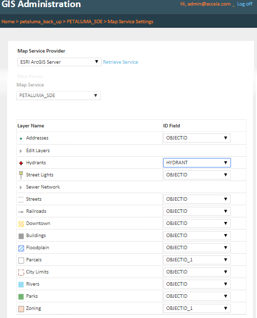
Map service layers
The Retrieve Service link on the Map Service Settings page retrieves the map services that are available from the configured map service provider, and displays the map services on the Map Service dropdown list.
When you select a Map Service, its map layers are listed. Each map layer has an ID field dropdown list which displays the layer's available attribute fields. By default, the ID Field dropdown value is set to OBJECTID, which indicates that Accela GIS uses the default ID on the map layer.
- You specify the field within the geodatabase feature class table that you want to map to the Accela GIS database. Accela GIS uses the ID field value to create the GIS object on the Accela GIS database.
- The ID Field connects the map layer in your map provider’s geodatabase to the Accela GIS database. For example, if you select HYDRANT as the ID Field for Hydrants (as illustrated in Figure 1), then objects in the Hydrants map layer are identified by the HYD_NUMBER field in the Accela GIS database.
- The ID Field values for each feature class in the geodatabase must be unique and fixed.
- The ID Field value will be automatically displayed when a map user selects or edits a GIS object on the map layer.
- The ID Field value is required on the GIS Object information panel.
Figure: Map service layers and their ID fields
The map layers from the configured map service become available, visible, and/or editable to the Accela GIS users according to the Integration > User Groups settings.