Accela GIS Prerequisites and Configuration Summary
The following table summarizes the prerequisites and required configurations for Accela GIS (JavaScript version). Note that Accela GIS refers to the JavaScript version, while the Silverlight version is referred to as Accela Silverlight GIS.
Important: To help you towards a successful Accela GIS installation and configuration, follow all the steps listed in the prerequisite checklist. A missed prerequisite or configuration will require you to fully uninstall and reinstall Accela GIS.
| Prerequisite | Required or optional? | Reference information |
|---|---|---|
| Install Accela GIS. | Required | Accela GIS Installation Guide |
| Configure security settings. | Required | Securing Communications |
| Configure ArcGIS Server and ArcGIS Engine Prerequisites. | Required | ArcGIS Server Prerequisites |
| Configure initial system administration setup. | Required | Initial Setup for Accela GIS System Administration |
| Configure Accela GIS integration with Civic Platform. | Required | Civic Platform and Accela GIS Integration |
| Accela GIS integration with Citizen Access | Required if agency is using Citizen Access | Citizen Access and Accela GIS Integration |
| Configure Geocoding Map Service Prerequisites. | Required if agency is using Geocoding map services. | Geocoding Service Configuration |
| Configure Feature Service Configuration. | Required if agency provides GIS features and layer editing capability to your users | Feature Service Configuration |
| Configure APO and XAPO Features in Civic Platform. | Required if agency intends to leverage APO and XAPO integration features with Civic Platform. For example, auto-populating and synchronizing APO data with records. | Accela Civic Platform Configuration Guide > Configuring and Enabling APO and XAPO Features |
ArcGIS Server Prerequisites
Accela GIS supports GIS services published to ArcGIS Server. To integrate with Accela GIS, you must purchase a license for one of the aforementioned ArcGIS Server versions.
See the configuration prerequisites for ArcMap, ArcCatalog, ArcSDE, MXD, and ArcGIS Server in Accela GIS for ArcGIS Server Configuration Guide.
Additionally, you must publish a map service in ArcGIS Server. ArcGIS Server hosts the map service for Civic Platform 8.x and later.
Initial Setup for Accela GIS System Administration
After installing the Accela GIS server component, the system administrator must perform initial agency setup on the the Accela GIS Administration site ("GIS Admin").
The Accela GIS system administrator is the first user of the GIS Admin site. The system administrator account and password are defined during the installation of the Accela GIS server component. After the Accela GIS installation, the system administrator must login to GIS Admin to perform the following initial setup:
Change the system administration account password on the login page.
Add the first agency on the Agency section of GIS Admin.
After adding the agency, the system administrator can either continue with configuring the agency’s initial map profile and product integration, or assign this responsibility to the agency administrator (to be created in the following step).
Add the first agency administrator on the User section of GIS Admin. An agency administrator can manage Accela GIS configurations only for his or her assigned agency.
Note:This step is optional. An agency administrator can register himself or herself on the GIS Admin login page.
- Managing Agencies - for information about how to add the first agency
- Managing Agency Administrators - for information about how to add the first agency administrator
HTTPS Configuration
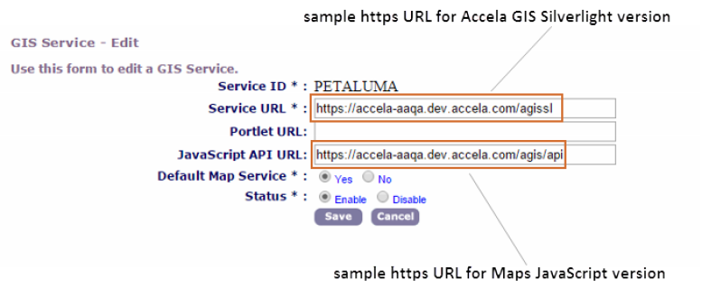
Civic Platform requires HTTPS connections with the Accela GIS (JavaScript) component. When configuring a GIS service in Civic Platform, the service URLs for the JavaScript version must specify https. If your agency uses Accela Silverlight GIS to support EMSE scripts, XAPO data sources, and proximity alerts with Civic Platform 8.x, the Service URL for Accela Silverlight GIS must also use https.
Geocoding Service Configuration
If your agency plans to use geocoding in your map integration environment, you must configure geocoding map services.
Geocoding is the ability to find a location, such as a street address, based on existing geographic data. For example, you might want to use to identify a specific street address and plot the address on the map. can identify and plot the address using existing GIS data, such as the street name and the range of even-numbered and odd-numbered addresses.
If you plan to use geodata for offline data mapping, then you must add the data to the geodatabase prior to configuring.
Feature Service Configuration
If your agency needs to provide GIS feature and layer editing capability to your users, you must set up ESRI’s feature service on the ArcGIS Server. For details about how to configure a feature service and publish it to ArcGIS Server, see ArcGIS Server documentation > Feature Services.